
The GeoVisual Geodata Collection - your go-to-ressource for georeferenced plans

Entdecken Sie unsere umfangreiche Sammlung von hochwertigen  Datenquellen für DACH (alle deutschen Bundesländer, Österreich und die Schweiz).

Über die Karten können Sie schnell und einfach auf die benötigten Informationen zugreifen.

Importieren Sie die passenden Geodaten, integrieren Sie Ihre Planungen und infrastructure plans Sie Ihre Projekte mit nur wenigen Klicks automatically. Egal, ob Sie GIS-Experte, Planer oder Ingenieur sind, unsere Sammlung bietet Ihnen eine Vielzahl von Datenquellen, für unterschiedliche Bedürfnisse. Von digitalen Orthophotos (DOP) über Geländemodelle (DGM) bis zu 3D-Häuserdaten (LOD2), stellen die meisten Bundesländer ihre Daten auf ihren Geoportalen kostenlos zur Verfügung.
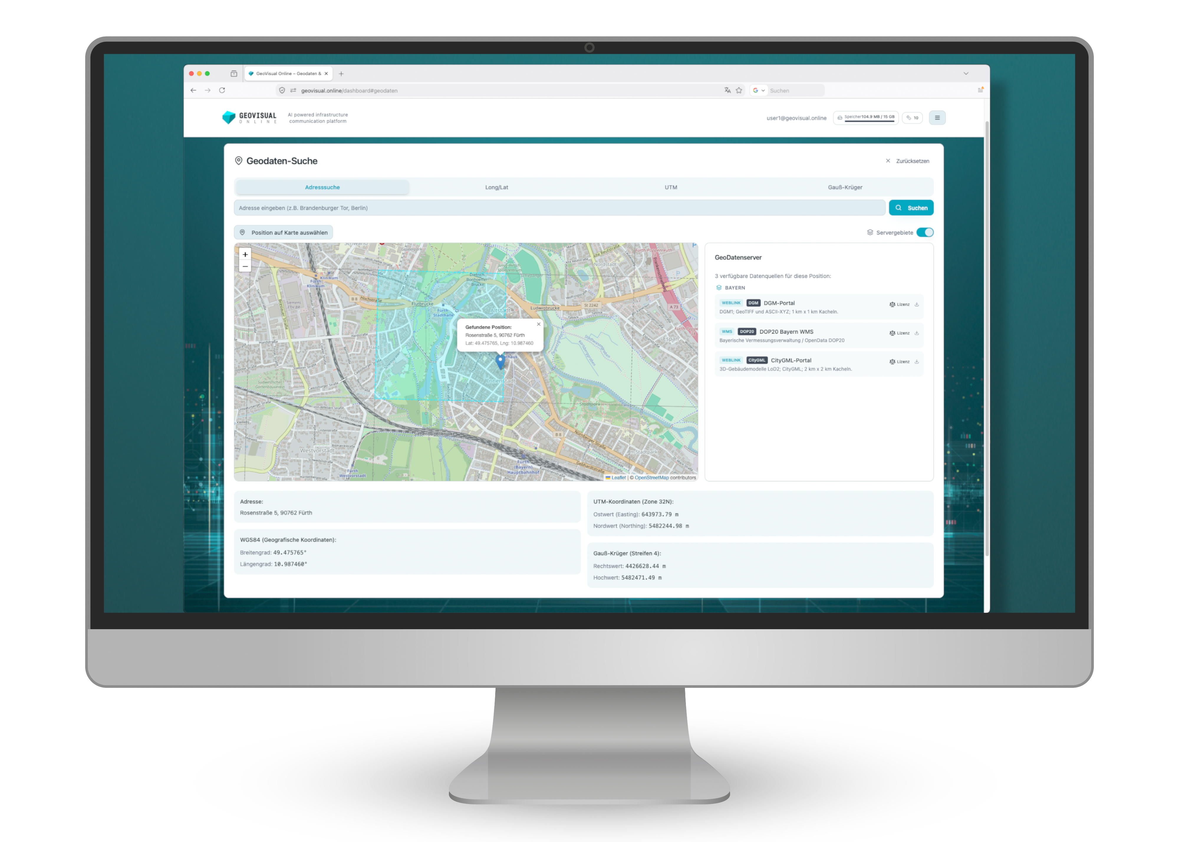
geovisual.online

Auf unserer Plattform finden Sie eine wachsende Anzahl direkter Geodaten-Downloads. Hier können Daten auch Konvertiert werden, falls Sie die öffentlichen UTM Daten z.B. in einem Gauß-Krüger basierten Projekt verwenden möchten.

Germany

Just click on the desired state. The link will lead you directly to the respective geoportal.

Load suitable geodata directly into your first GeoVisual project and test all the basic functions together with your own project data. Register now for your free GeoVisual test account.

free trial!

Switzerland

Austria

We are constantly expanding and updating our GeoVisual Geodata Collection. Here you can find the links to the geoportals of other European countries and South America.

To visualize a standard project in GeoVisual you need:

1. a digital elevation model (DEM),

2. a digital orthophoto (DOP)

3. building data (LOD)

Add further data to your visualization at any time.

 u

Abbreviations

CityGML (City Geography Markup Language) is an open data standard for the storage and exchange of virtual 3D city and landscape models. It was developed to provide a common definition and structure for 3D city models that supports a wide range of applications in urban planning, geographic information systems (GIS), telecommunications, civil protection and more. CityGML defines different Levels of Detail (LOD), ranging from simple block models (LOD1) to very detailed models with interior structures (LOD4).

DOP (digital orthophoto) is an aerial image or satellite image that has been geometrically corrected. This means that it is free of distortions. The number after DOP indicates the resolution. The resolution of 10 meters, for example, means that one pixel in the image represents an area of 10 x 10 meters on the earth's surface. The lower the number, the higher the resolution and thus the level of detail in the image.

DEM (Digital Elevation Model) represents the earth's surface without any objects such as trees, buildings or other structures. The number after DTM indicates the resolution. For example, a resolution of 10 meters means that one pixel or data point represents an area of 10 x 10 meters.

DTM (Digital Terrain Model) in some countries is synonymous with a DEM. In the United States and other countries a DTM is a vector data set composed of regularly spaced points and natural features such as ridges and breaklines. It also includes linear features of the bare-earth terrain.

LOD2 (3D Gebäude mit Detailstufe 2)
3D-Gebäude der Kategorie “LOD2” (Level of Detail 2) beziehen sich auf eine spezifische Art der Darstellung von Gebäuden in dreidimensionalen Geodatenmodellen. Bei LOD2-Modellen werden Gebäude als Blockmodelle mit vereinfachter Dachstruktur dargestellt.

GeoTIFF is a file format used for geographic data. It is an extension of the popular TIFF (Tagged Image File Format), a standard for saving raster graphic images. GeoTIFF adds specific metadata to TIFF that contains geographic information.

A TFW file, also known as a TIFF World File, is an accompanying file to a TIFF image (Tagged Image File Format) that contains geographical reference information.

WMS (Web Map Service) is a standardized protocol developed by the Open Geospatial Consortium (OGC). It enables users to access map images via the Internet. Rasterized images are always retrieved.

WFS (Web Feature Service) is also an OGC standard that enables the exchange of geodata via the Internet. In contrast to WMS, which provides maps as images, WFS enables access to the actual geodata, i.e. it can contain vectors, layers and/or rasterized images.

Both can be loaded into a geographic information system (GIS) using a "GetCapabilities URL" and displayed or exported from there.

An XYZ-file is a simple text file format that is used to store spatial coordinates.